

To honor the 50th anniversary of Earth Day and 20th anniversary of NASA’s Earth Observatory, the agency asked people to choose the best image of Earth from space. After a five-round tournament and more than 56,000 votes, the readers chose their favorite one: Ocean Sand, Bahamas (2001).
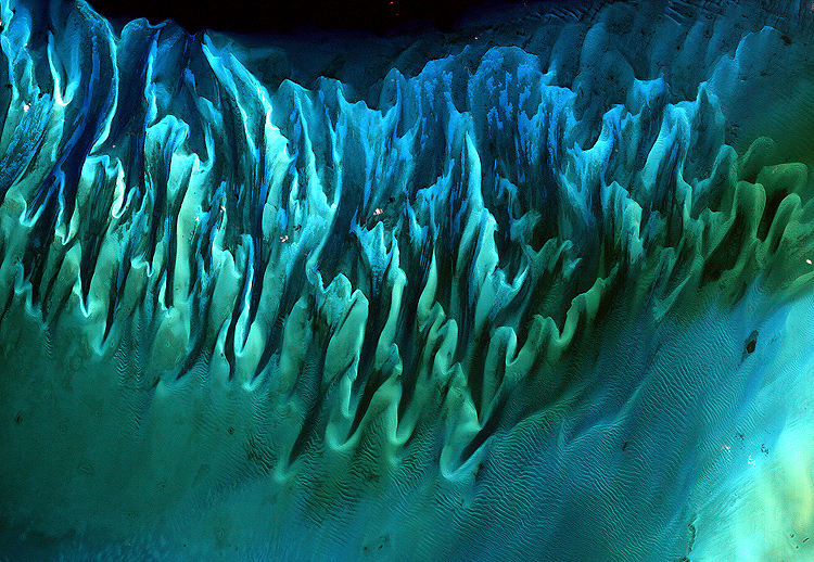
The winning photo captures sand and seaweed in the Bahamas using the Landsat 7 satellite. It was taken in 2001 by Serge Andrefouet, a remote sensing specialist at the University of South Florida.
The image might resemble a new age painting straight out of an art gallery in Venice Beach, California, but it is a satellite image of the sands and seaweed in the Bahamas
NASA
The image was taken by the Enhanced Thematic Mapper plus (ETM+) instrument aboard the Landsat 7 satellite. Tides and ocean currents in the Bahamas sculpted the sand and seaweed beds into multicolored, fluted patterns in much the same way that winds sculpted the vast sand dunes in the Sahara Desert.
Raikoke Erupts (2019)
An unexpected series of blasts from a remote volcano in the Kuril Islands sent ash and volcanic gases streaming high over the North Pacific Ocean. On the morning of June 22, 2019, astronauts shot a photograph of the volcanic plume rising in a narrow column. “It then spread out in a part of the plume known as the umbrella region,” wrote NASA.
That is the area where the density of the plume and the surrounding air equalize and the plume stops rising. The ring of clouds at the base of the column appears to be water vapor
NASA

Where the Dunes End (2019)
Mountains of sand, some as tall as 300 meters, reach from the floor of Africa’s Namib Desert toward the sky. Driven by wind, the dunes march across the desert. They are bordered to the west by the Atlantic Ocean and in other directions by rocky surfaces.

Twin Blue Marbles (2007)
The view of Earth from space is a fusion of science and art, drawing on data from multiple satellite missions. The twin images of Earth are a composite of multiple images taken between 1994 and 2004.

Fire in the Sky and on the Ground (2011)
Astronauts on the International Space Station used a digital camera to capture several hundred photographs of the aurora australis or Southern Lights while passing over the Indian Ocean on September 17th, 2011.

Retreat of the Columbia Glacier (2014)
Scientists have long studies Alaska’s fast-moving Columbia Glacier, a tidewater glacier that descends through the Chugach Mountains into Prince William Sound.


View of Earth from Saturn (2006)
Have a look at Earth appearing as a bright dot. Seen from a billion kilometers away, through the ice and dust particles of Saturn’s rings, that’s the way earth looks. The image is a composite made from 165 images taken by the wide-angle camera on the Cassini spacecraft.

The Dark Side and the Bright Side (2015)
A NASA camera aboard the Deep Space Climate Observatory has captured a unique view of the Moon as it passed between the spacecraft and Earth. A series of test images shows the fully illuminated dark side of the Moon, which is not visible from Earth.

A Voyager Far From Home (1977)
The image of a crescent-shaped Earth and Moon was captured on September 18, 1977 when Voyager was a mere 11.66 million kilometers from Earth and directly above Mount Everest.


