

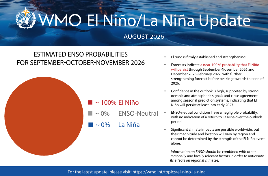
From October 2026, travel planning will demand closer attention to weather risks. El Niño is established and expected to strengthen before peaking late in 2026. The World Meteorological Organization (WMO) puts the probability of El Niño conditions persisting through December 2026–February 2027 at nearly 100%, with climate effects potentially lasting longer.
This is not a universal forecast. El Niño alters rainfall, heat and atmospheric conditions, while other ocean patterns can strengthen or weaken its effects. Still, travellers and operators should prepare for disruption from floods, drought, heat, wildfires and storms, as well as pressure on water, food and transport.
A changing map of risk
Heavy October–December rains in parts of the Horn of Africa could raise flood risk and disrupt safari roads and camps. Southern Africa has a clearer dry signal: the European Commission’s Joint Research Centre (JRC) forecasts drier-than-average conditions across South Africa, Namibia, Botswana, Zimbabwe, Mozambique and Madagascar during the 2026–27 summer. Below-normal rainfall is also more likely in parts of Central America, South-East Asia, the Maritime Continent and, later, north-western Australia. These are regional probabilities, not destination-level guarantees.
Strong El Niño events can bring heavy rain and flooding to western South America, but travellers to Peru or Ecuador should follow national and local forecasts. In the United States, wetter-than-normal conditions are more likely across much of the southern tier. Pacific storms may also shift towards California, raising the risk of heavy rain and flash flooding, although a uniformly wet western winter is not assured.
El Niño usually suppresses Atlantic hurricanes by increasing wind shear. The US National Oceanic and Atmospheric Administration (NOAA) gives the 2026 season a 55% chance of below-average activity, but Caribbean hurricane risk remains.
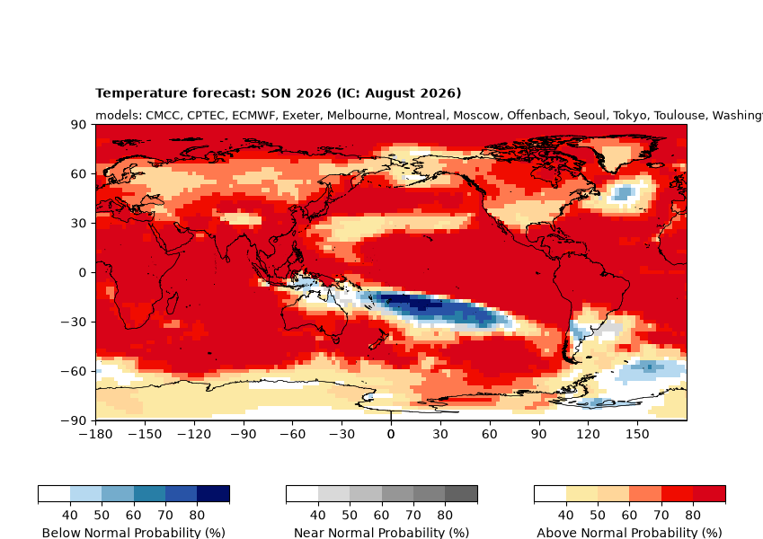
Drought is possible across parts of the Caribbean and Central America, with conditions varying by place and season. Europe’s response is less predictable: the JRC sees a possible warm anomaly in autumn, potentially strengthening in spring 2027. Travellers should prioritise destination-specific forecasts and official warnings.
What can the industry do?
Airlines, tour operators, hotels and destination managers should link contingency plans to official alerts, with alternative routes, backup accommodation, flexible staffing and clear shelter or evacuation procedures.
Contracts should explain what happens when weather closes roads, ports or attractions. Businesses also need water and energy plans for drought-prone destinations, resilient suppliers and guest updates that distinguish official warnings from seasonal outlooks. Cruise, safari and adventure operators should review route access, wildfire exposure and medical support.
How travellers can protect their plans
Travellers should consider flexible bookings, allow extra connection time for connections, and avoid itineraries dependent on one road, flight, or ferry. Before buying insurance, check cover for known events, weather disruption, missed departure, evacuation and cancellation, bearing in mind that the WMO’s near-100% warning could push travel insurance premiums up too.
Monitor national weather services and official travel advice before and during the trip. Save alerts offline and keep medicines, key documents and emergency contacts accessible.
For hot-weather trips, carry water, seek shade, and avoid the hottest hours. In drought-hit destinations, respect restrictions and reduce water use. Marine heat can damage coral, so divers should check current reef and marine-park advisories.
Shoulder-season travel or lower-risk alternatives may help, but even “coolcations” can face disruption. As Travel Tomorrow has already reported, flexibility is becoming a core travel skill.